
Zur deutschen Fassung dieses Artikels.
Reading the book Black Earth, I became aware of a village in Ukraine that was calculated and named as the geographical center of Europe in 1887: Dilove.
“Really?“ I wondered, not because I would begrudge Dilove the distinction, but because I had already visited the alleged center of Europe a few years ago, in the aptly named Europe Park in Lithuania.


The underlying calculation in this case dated from 1989.
Over a hundred years, it may be possible for a continent to grow a bit, shrink a bit or move around a bit. After all, the continental drift had been invented in the meantime. But from Ukraine to Lithuania, that’s a stretch – at least geographically. Different methods of calculation must have been used.
The first problem is to determine what Europe is. Do you do it politically? Then it would be the Habsburg Empire or the European Union. With or without candidates for accession? Will the United Kingdom suddenly be (even) less European in two years? And what is the effect of that Swiss hole in the middle of the European cheese? Do you include the islands which expand the territory of the EU all the way to Guadeloupe and New Caledonia? Aren’t French Guyana and Ceuta so obviously in South America or Africa, respectively, that they cannot be part of Europe? What about Northern Cyprus? Questions upon questions. Good that at least Germany lost everything from Samoa to the Bismarck Archipelago, for otherwise the map of the EU would be even more complicated.
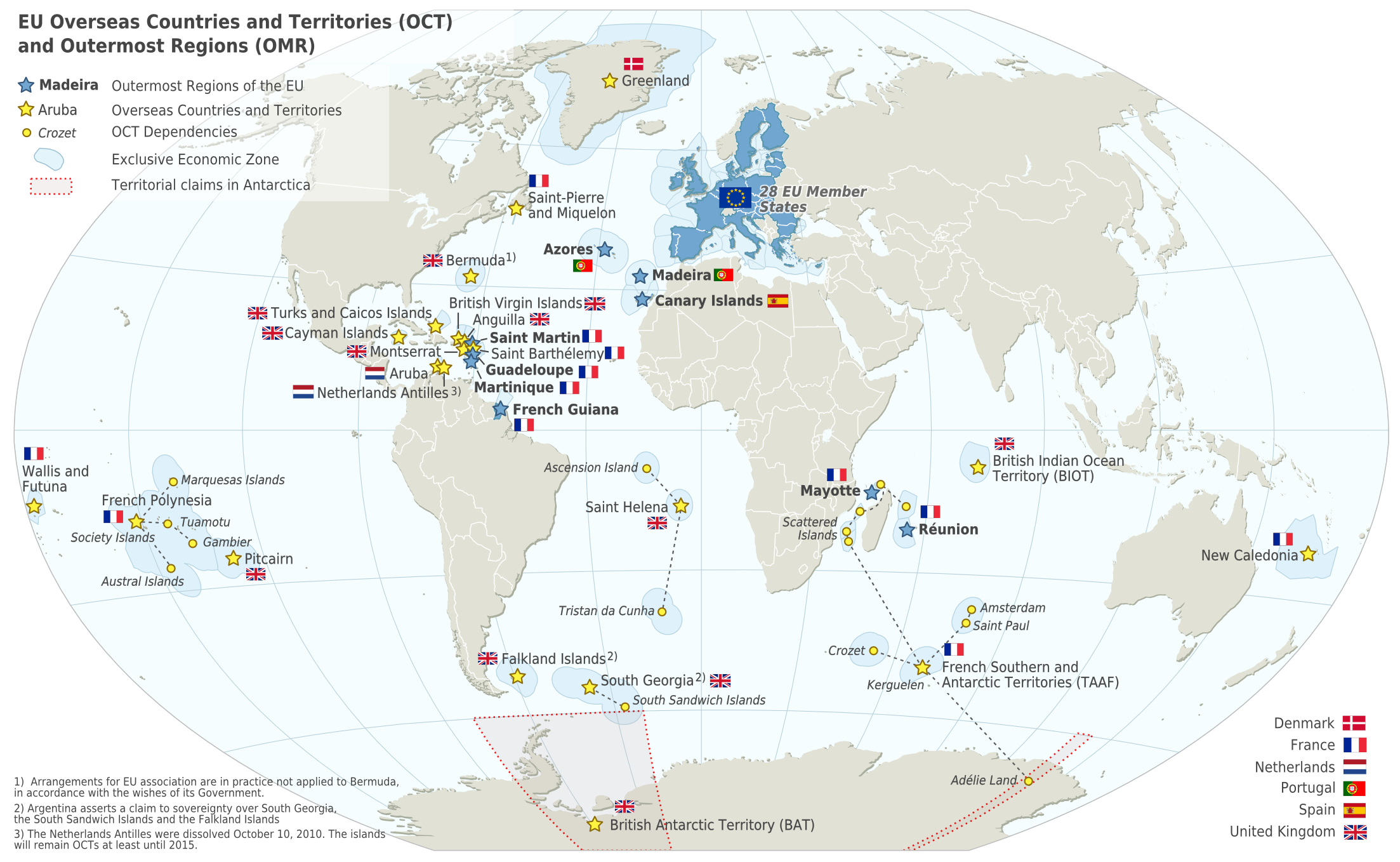
But even leaving political interpretations aside, a mere geographical calculation of the center of the continent can be debated endlessly as well. Where to draw the Eastern boundary? What about Turkey? What about the Caucasus? Is Malta European or African? Do you simply connect the most outward points to determine the center? Or do you consider the boundaries of the landmasses? Possibly weighted for the product of surface times density, because an acre of Switzerland weighs more than an acre of Holland. Or do you pick the center of a circle drawn around Europe?
If you are playing around with methods and figures, you will always find some center of Europe situated in a small village hoping to benefit from Euro-centrist tourism. Because it is striking that all centers of Europe have so far been in villages in the pampas where nothing else is happening:
- Suchowola, Poland
- Stará Voda, Czech Republic
- Neualbenreuth, Germany
- Hildweinsreuth, Germany
- Dilove, Ukraine
- Krahule, Slovakia
- Purnuškės, Lithuania
- Westerngrund, Germany
- Polotsk, Belarus
- Tállya, Hungary
- Mõnnuste, Estonia
But I don’t think there is much to see at either of these places. Well, Mõnnuste at least is on the island of Saaremaa, which looks quite beautiful.


Pingback: Wo ist die Mitte Europas? | Der reisende Reporter
“…an acre of Switzerland weighs more than an acre of Holland.” LOL.
I would think that the most logical way to calculate the center of Europe would be to use Europe as a continent with its set continental borders (Ural mountains, Caspian sea, Caucasus mountains, Black sea, Bosphorus strait – so Istanbul in, Ankara is out), leave out any offshore islands (or add in the ones that are on the same continental shelf, like Britain and Sicily), and find the center of mass of the resulting figure: basically, if you cut out a map of Europe’s land mass as a sheet of iron or plywood, the center would be such a point where you can put an axis in and the Europe will rotate on it like a wheel.
Just the map or a 3D-replica? Because the different weight of mountains will shift the balance.
I meant just the 2D map, since that would be the simplest representation. But you could do it with a 3D replica, too, of course, and would get a different center.
And it would keep moving as cities get built/expanded.
Pingback: Lithuania: Eastern Europe or not? | The Happy Hermit
Tállya, Hungary is part of the world famous Tokaj wine region, so there is definitely one thing the visitor can do there.
And castles, wonderful woods and hills for hiking, historic towns and villages nearby.
That sounds fantastic!
One of my big dreams is a long walk across Europe, a bit in the spirit of Patrick Leigh Fermor, and I am curious about Hungary in that respect. Some people say it’s too flat, others report that it’s quite interesting and beautiful. I need to find out myself.
Now THAT sounds fantastic!!
Yes we have the Great Plain and a small one, but you will want to check out the National Blue Trail, it goes through the most beautiful parts of Hungary, mountains, the Danube Bend (that’s where I live now) and others.
Yes, that’s exactly the trail I had read a very positive review about! (I had forgotten the name, although it really shouldn’t be very complicated to remember.)
Cool!
Tállya is just a few km-s away from this route.
And I actually live on the trail – so let me know, if you have questions when you get there.
You might see me from afar because I will wear this distinctive hat – from Erdély, of all places: https://andreasmoser.blog/2015/12/31/hats/