
Zur deutschen Fassung dieses Artikels.
Under the bewildered eyes of those going to warm offices, schools and shops, I am the only one to exit the bus at Signal de Botrange. Because the clock went crazy the last weekend, the sun isn’t quite sure whether to get up already or whether to hit the snooze button one more time. Behind the clouds, it is wafting in some interim state.
694 meters don’t sound like much, but I am at the highest point in Belgium. Therefore, it’s not only ice-cold, but also extremely windy. In spring, I had cockily left behind the winter coat, hat and gloves in Canada, thinking that it would never be as cold in Europe. And now I am shivering as if I was at the North Pole. My hands are turning red, my fingers are freezing stiff, and I can hardly grasp the pen, let alone write legibly.
On a viewing platform, there is a gentleman who is visibly better equipped and wrapped in wool, looking for birds. Even his binoculars are better protected against the wind than I am.
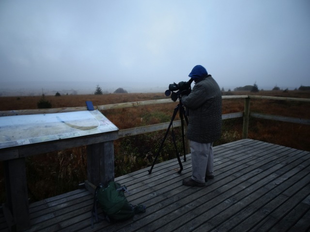
“Today is not a good day,” he explains. A bad omen. “There were too many westerly winds in the last days. Now the birds are taking the route across the Eifel. But on Thursday, we saw 12,000 cranes here. ” Because the birds are smarter, they are moving south now.
As the ornithologist learns that it is my first visit to the High Fens, he walks with me to a hiking map on a wooden board, even taking the risk of missing thousands of birds. He recommends that I walk around the core area of the High Fens. “You look like you can walk a lot,” he appraises me correctly, generously ignoring the insufficient protection against the biting cold.
I had actually planned to walk in a completely different direction, but: “On that way, you will get the best impression of the Fens.” I don’t really know the difference between fens, marshes and bogs, but the High Fens are obviously raised swamps. As everyone knows, those are much more dangerous than low swamps, just as falling from a cliff is deadlier than tripping over the curb.

Because the birdman seems to be here regularly, I ask him for the best time for hiking. “Now it’s actually the prettiest,” he answers, while I am looking over fog-covered meadows, shivering from the cold. “In spring, too many paths are closed. In summer, there is the threat of wildfires. Now, in late fall, the Fens look like are supposed to look.”
I change my plan for the day because if someone knows how many birds are flying to where on what day, he surely knows the best hiking trails too.
The lack of colors in the landscape makes me suspect that the birds are moving to Sicily or Morocco mainly out of boredom.


But the vultures might as well stay behind. Again and again, I find crosses reporting of hikers that froze to death, got shot, or whose skeletons are still stuck in the swamp.


The last cross was erected for the young couple Maria Solheid and François Reiff, recently engaged, who ignored all warnings in January 1871 and left to cross the High Fens with insufficient clothes. That plan sounds familiar. Their corpses were only found in March 1871, after the snow had melted.
Next to the lovers’ cross, there is an information panel: “In case of emergency, call 112. To convey your exact position, mention RVP number 430007.” Very well organized and thought out, but the mobile phone has no signal.
I am unsure whether to believe the lovers’ story because the cross is suspiciously close to boundary stone no. 151, displaying a large B for Belgium on one side and a large P for Prussia on the other. Maybe they were smugglers? Or spies?


The almost completely uninhabited landscape was always a good area for borderlands, between the principalities of Liège and Stavelot-Malmedy, between the duchies of Luxembourg, Limburg and Jülich, between the Netherlands and Prussia, then between Belgium and Prussia, and ultimately between Belgium and Germany.
Thanks to the European Customs Union, there is no more smuggling, but you can still die a gruesome death in the moor.

I try to pay a bit more attention than I usually do, looking more on the ground than into the grey sky. The most treacherous parts are covered with wooden planks, flanked by previous paths already sinking and decaying. Two workers are repairing the current pathway and tell me that a great many trails were destroyed in the great fire of April 2011. Good that I don’t have a cigar in my mouth as I encounter them, or they might blame me.


The hiking trails are not the only thing being worked on. The whole landscape was remodeled to make it swampy (again). From 2007 to 2012, around 7400 acres were renaturalized. Spruce trees were cut down. The top soil was removed, allowing moorland herbs to grow again. Old moors were made wet again. You feel a bit like on a construction site, not in nature. But then, what is nature really? 2000 years ago, the area was covered with forest, and only since the Middle Ages did agropastoral cultivation lead to a heathland. The marshland thus created was later cleared of the water to cut peat. Renaturation is thus just the creation of an erstwhile state, arbitrarily chosen from time, but definitely not the recreation of the original natural state.
The walk takes several hours, but remains uneventful. No bog mummies. No jack-o’-lanterns. And the hound of the Baskervilles has been barred anyway.

Hiking itself has not been banned altogether, but the wooden planks really dictate the path. This may be helpful for people who tend to struggle with orientation. But for me, who likes to roam freely, it feels too much like I am being guided, led, like a train on tracks.
Thus, without having any other choice, I reach Baraque Michel, again on the main road through the High Fens. But the house is much older than the road. Back then, the High Fens were really dangerous. In 1794, Michael Schmitz almost sank and made a vow. In case of survival, seeming quite improbable at the time, he wanted to dedicate his life to save other victims of the moor. He did survive and built a simple structure, called Baraque Michel. His children continued the work and over time, more than a hundred people were saved. Donations of survivors made the house grow bigger, and with money, compassion was replaced by capitalism. Nowadays, lost hikers are no longer rescued, but are charged 28 € for a flambéed fawn steak in cognac and cream sauce.
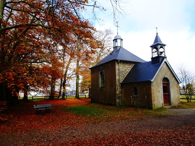
At Fischbach Chapel, you can still see that it has a bell tower and a lighthouse, both once intended to aid orientation.
Less optimistic or hardship-resistant hikers would now conclude the day. It is cold, it is grey, it’s lunchtime, and one could catch the bus back to Eupen from here. But for me, it’s time to unpack the original plan of exploring the western half of the nature park, hiking in a somewhat southerly direction, towards Malmedy.
And what happens? The sun is coming out. It’s getting warm. The colors are turning green and blue and red and yellow. The creeks are bubbling cheerfully. The cigar glows happily. Rabbits and deer are dancing in the fields. The author jumps from stone to stone to avoid drowning.


All of this I would have missed, had I thrown in the towel after the miserable morning. You are welcome to draw some lesson from this, if you insist.
Somewhere in the forest, there is a weather-beaten wooden sign pointing to Reinhardstein Castle. I have no idea if I am still walking towards Malmedy anyway, so I spontaneously discover my enthusiasm about the prospect of a castle. Walking along an overgrown creek, I walk higher and higher, until I have to climb up a hillside which is so steep and cleared from trees that one wrong step would send me rolling back down into the creek. I can’t see any castle.
Exhausted, I sit down on a stump, light a cigar and soak up sunshine and tobacco. And there I see it, on the other side of the canyon: Reinhardstein Castle, first built in 1354. Majestically, it sits on a natural throne, wearing a dress of autumn-colored leaves.


I would like to take a closer look at the castle, knowing of the readers’ curiosity, but the closer I get, the more screams I hear. Each of them shriekier than the other. And even worse: they are the screams of children! Probably the four sons of Aymon, still hiding from the bailiffs of Charles the Gruesome.

I am scurrying away through the dark undergrowth, in full panic mode. But at least I know the most beautiful spots in the High Fens now. I shall keep the secret as the moor keeps its.
Practical advice:
- From Eupen, TEC bus 394 is going through the High Fens. Baraque Michel or Signal de Botrange are good spots to get off. One ride costs 3.50 €.
- As I have experienced, hitchhiking also works well in East Belgium.
- For cyclists, the Vennbahn cycling route might be of interest. It leads 125 km along an old railway line and also through the High Fens. You can cycle all the way from Aachen across Belgium to Luxembourg.
- The “Path of Remembrance”, a history/hiking path, also leads through the High Fens. As a history student, I should actually tackle the 96 km one day.
Links:
- More articles from Belgium.
- Further hikes.


Pingback: Morgens schaurig, nachmittags schön | Der reisende Reporter
Love it! (your photography is getting better too)
Thank you, Sir!
I noticed that professional photographers actually edit their photos with some kind of computer programme, changing colours and stuff.
But still, it’s so much work, I would much rather just write and have someone else take the photos. (hidden hint ;-) )
Beautiful written poetic piece, accompanied with some of the most amazing autumn photos. Thank you so much for risking a frost bite to share this!
Thank you very much!
I have actually been back to a different part of the High Vens last Sunday for another massive hike, and it was beautiful again.
I am already curious to explore it in the other seasons.
so beautifully captured
Thank you!
Super account of an outstanding place.
Thank you very much!
And you have a great blog about your most interesting country. I found it via Tonio Privitelli’s blog https://antoniotravels.wordpress.com/ .
In 2019, I had a few house/cat sitting gigs in Antwerp, Bruxelles and in Chastre, so I got to know different parts of Belgium. And as a history student, I delved into a very complex history which was completely new for me. Last year, I went to Ieper with university, and I’ve been to the German Community a few times, especially after reading David van Reybrouck’s book about Kelmis.
I was planning to spend much more time in Belgium, but then, my ex-girlfriend who lives in Aachen fired me, and now I am trying to avoid that part of Europe, for fear of having my heart ripped out again each time something will remind me of that tragedy.
But I hope that in ten years or so, I will be over it and that I can come to Belgium again!
Perhaps you need a(nother) Belgian girlfriend to help you get over the Aachen heartbreak Andreas. Yes Kelmis is worth a few blog posts isn’t it? Hope it will be less than ten years before you set foot on Belgian soil again.
First, I need Aachen to be visited by the Allies the same way they did in October 1944. ;-)
It’s sad, because I really like that whole area where you can walk through the forests and be in a different country every 30 minutes. While hiking, I sometimes even overheard families speaking two or three languages between them.
I guess when you were in Ieper you came across the West Vlaams dialect. The first time I heard it I thought it was Hungarian.
:D :D
Let’s hope nobody from Ieper reads that.
It’s hard for me to say, because in Ieper everyone spoke English all the time, assuming I was British, like the majority of visitors.
Being German, it’s always strange for me to hear Dutch. It sounds so similar, and I feel that I should understand the gist of it, but I usually don’t.
Reading it is easier.